Heritage
Carrowkeel
Carrowkeel is a Neolithic hilltop passage tomb complex located on the northern plateaus of the Bricklieve Mountains. It contains 14 passage cairns identified and is one of a series of limestone plateaus aligned towards Knocknarea. Carrowkeel is one of the most spectacular and breath taking archaeological sites in Ireland.
Auriel Robinson, Wild Atlantic Way Ambassador and head guide of Seatrails, specialises in archaelogical walks and Irish heritage trails.
Carrowmore
Carrowmore is home to the largest and oldest collection of stone circles and dolmens known from Neolithic Ireland. These monuments are also among the country’s oldest, with the oldest pre-dating Newgrange by 700 years. Archaeologists have recorded over 60 tombs of which 30 are visible.
Carrowmore is one of the largest megalithic cemeteries in W. Europe and the guides and diagrams there can explain the significance of the Dolmens, Passage graves and stone circles around the visitor centre. Radiocarbon dating suggests 3,800 and 4,600 BC for two of the tombs.
Creevykeel Court Tomb
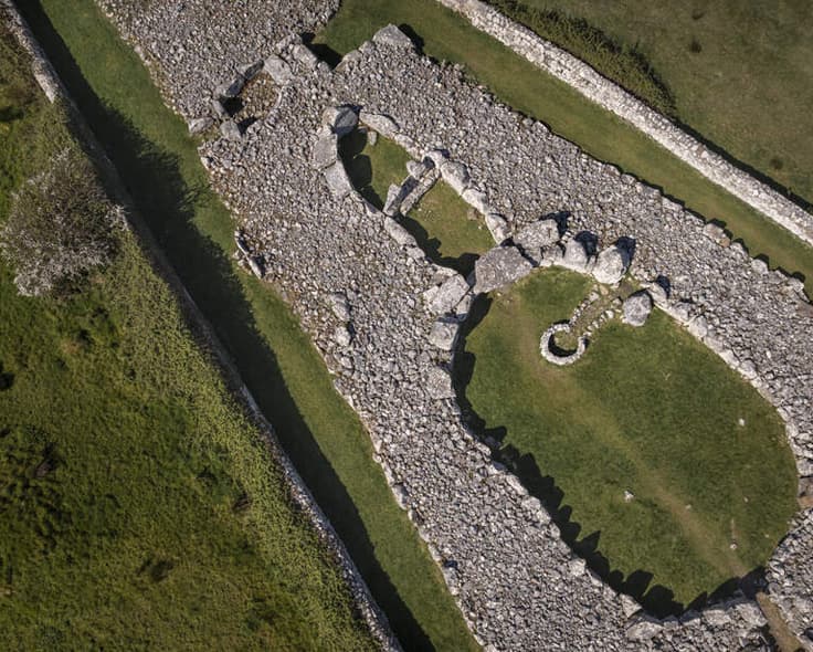
This monument is situated at the foothills of Tievebaun Mountain, near the sea at Mullaghmore, and is one of the finest examples in Ireland of what is known as a full-court tomb.
Dating from the Neolithic period (c. 4000 – 2500 BC) it consists of a wedge-shaped cairn about 50m long, incorporating at its eastern end an oval-shaped court.
The entrance into the court is at the east, and consists of a narrow passage-way lined with upright stones. The court is among the largest of its type in Ireland, measuring 15m long by 9m wide. From the court is the entrance to the burial gallery which is divided by upright stones into two chambers and was originally covered by a corbelled roof.
Queen Maeves Cairn
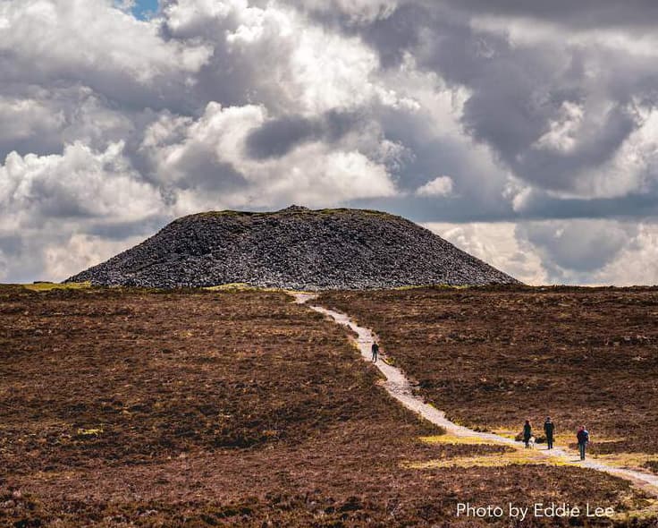
Queen Maeve’s Cairn, perched on the summit of Knocknarea, is one of the most impressive megalithic monuments remaining in Ireland. Knocknarea is the most prominent and beautiful mountain in County Sligo, it’s only possible rival being the majestic plateau of Benbulben.
Aside from Queen Maeve’s cairn, there are six more neolithic monuments, five on the summit, while an overgrown boulder circle is on the edge of the large lower ledge to the east. There are also the foundations of some 28 neolithic houses and 1.2 km of stone walls and banks on the south side of the summit.
The passage and chamber have remained hidden since prehistoric times. The cairn is known to be the resting place of the legendary Queen Maeve of Connaught; its good state of preservation is probably due to her fierce reputation. Maeve ruled Connaught from her palace at Rath Croghan near Tulsk in Roscommon, and she is best known for her role in the Tain Bo Culainge, where she led her province to war against Ulster to take the Brown Bull of Cooley, when Cuchullain single-handedly held off her army. That she chose to be interred in the Great Cairn of Knocknarea says something about its prestige as the most important and ancient sacred site in Connaught.
Gabrial Beranger’s 1779 record of Queen Maeve’s Cairn. Legend tells us that Maeve was buried standing upright within the chamber, with her armour on and facing her ancient enemies in Ulster. There are also stories of chieftains being buried in Knockma, Carns Hill and Heapstown. These legendary burial practices echo the Egyptian customs of burying the kings within the pyramids – in death, they act as symbolic and spiritual guardians of the landscape they once ruled.
Photo by Gareth Wray
The Glen, Knocknarea
This magical looking glen is more characteristic of a micro-valley. A few days ago I set out to find this hidden glen. After asking a few locals for directions I still passed the entrance twice before even realising. The entrance is basically a hole in a hedge & there are no signs which is a pity as this place truly deserves to be seen & appreciated by our modern generation.
Entering the deep chasm is like entering a walkway to another world! This glen is carved deep into limestone rock for almost 1 mile. There are many specimens of trees & plants growing here that look like they belong in a tropical rain forest. Vines drape from the tree canopy above right down to the valley floor & fresh rain water treacle’s down the uniformed walls on each end which are 60 ft in height along the entire length of the glen.
This glen/valley is near the sacred hill of Knocknarea where the ancient queen Maeve of Ireland is buried on top. There is archaeological evidence that proves our ancestors carved rock from this glen thousands of years ago to use as Dolmen tombs across County Sligo, Ireland. Theory also states that they may have used this valley for ceremonial & ritual practices.
Access to the Glen can be difficult: it is a pretty overgrown spot. Trees and branches fall across the pathway, and during the wet weather often experienced in Sligo, there are often large, deep pools of mud to be crossed. Unless the weather has been dry for weeks, wellingtons or stout boots are essential.
Ceide Fields
Beneath the wild boglands of North Mayo lies Céide Fields — the world’s most extensive Stone Age monument, featuring 5,000-year-old field systems, dwellings, and megalithic tombs. The surrounding bog flora is of international importance and bordered by some of Ireland’s most striking cliffs and rock formations.
The discovery began in the 1930s when local schoolteacher Patrick Caulfield noticed piles of stones beneath the peat while cutting turf. Realising they were man-made and ancient, he sparked curiosity that decades later led his son, archaeologist Seamus Caulfield, to uncover their true significance.
Excavations revealed a vast Stone Age landscape of walled fields, houses, and tombs preserved beneath the bog. Research using simple, non-invasive probing methods has since provided remarkable insight into a peaceful, organised farming community that thrived 5,000 years ago — skilled in stonework, woodworking, and deeply spiritual.
At the Céide Fields Centre, visitors can explore exhibitions, including a 4,300-year-old Scots Pine tree, and enjoy an audio-visual show. The pyramid-shaped glass building also features panoramic viewing platforms offering stunning sea and land views.
Photo by Gareth Wray
Knocknashee, Hill of the Fairies
Knocknashee ‘Hill of the Fairies’ is one of Ireland’s largest Bronze Age fortified hilltop forts stretching 700×320 meters across this table-top mountain plateau. Being one of Ireland’s seven most sacred hills, its name comes from the Irish words “knock” (cnoc) meaning “hill” and “shee” meaning “fairy”.
And there is nowhere better to begin a visit, and to experience all of these sensations and emotions, than on the Hill of the Fairies, or Knocknashee, about 10km north of Tubercurry. Along with the stone chambers of the Carrowkeel Tomb Complex and the mysterious depths of the Caves of Kesh, this airy limestone plateau was always a “holy”, or spiritual place among south Sligo’s rich constellation of such places. Michael Gibbons, one of Ireland’s leading field archaeologists, was much impressed with this hill, calling it a “place apart” and “one of the great European hill-forts”.
Guided walk in the company of John Barrett, of Wild Wet Adventures (tel 086-7222750), who runs a range of outdoor activities, including guided walks, in the area.
Barrett took us the 1km from the ample parking at Court Abbey (well worth a visit), and we respectfully entered a working farm at a sign indicating an agreed route up the hill. He then brought us up the steep grassy slopes, over the hill-fort’s now undefended “ramparts” to the Stone Age summit tomb-cairns, and showed us the subtle indentations of the dwellings of our more recent Iron Age ancestors.
He pointed out for us Croagh Patrick in the distant haze, Ireland’s holiest mountain, and Benbulben, one of our most iconic, and everything in-between. Then he encouraged us to ramble awhile, and just “feel” and enjoy the place, in the gentle sunshine of that day.
Parkes Castle
Rising three storeys tall, in an idyllic setting on the banks of Lough Gill, in County Leitrim in Ireland, Parke’s Castle is a plantation era castle. In 1610 Roger Parke completed his fortified manor house on the site of an earlier fifteenth-century O’Rourke (Uí Ruairc) castle. He kept the walls of the original bawn and demolished the O’Rourke tower house in the centre. Some of the stones from the O’Rourke’s tower was used to build the three-storey manor on the east side, eventually adorned with mullioned windows and diamond-shaped chimneys.
Inside the courtyard are many stone work buildings and a covered well. There are also a postern gate and a sally port and there used ot be a most her too. Excavations in 1972-73 revealed the base of the original O’Rourke tower house beneath the courtyard cobbles, and this is now exposed to view. It was in this tower house that Francisco de Cuellar, the shipwrecked Armada officer, was entertained by Brian O’Rourke. In later years, de Cuellar was to write of his host: “Although this chief is a savage, he is a good Christian and an enemy of the heretics and is always at war with them.” O’Rourke was eventually captured, indicted and executed for high treason in London in 1591.
The castle had extensive and sensitive restoration carried out at the end of the 20th century by the Office of Public Works. The window glazing was reinstated, and local artisans restored the timber stair and the mortise and tenon oak roof, using techniques of the 17th century.
Opening Times/Admission Charges : Open: approx 21st April – 28th Sept. 10.00 – 18.00. Last admission 45 minutes before closing. Average visit: 1 hour.
Audio Visual Presentation : Stone by Stone Seating: 40 Duration: 20 mins. Languages: English, French, German and Italian.
Facilities : Exhibition, toilets and toilet for visitors with disabilities. Public car/coach park close to site. Restaurant/Tearooms: Open during the high season
Guided Tours Available : Guided Tours: Available on request Maximum No: 25 Duration: 40 Minutes